How Open-Source Analysts Dismantled the EO-3 Image Fabrications Within Hours

S Ahmad

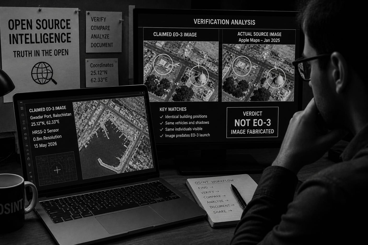
“The dismantling of the EO-3 fabrications demonstrates a fundamental shift in the information landscape—verification is no longer the monopoly of states or institutions, but a distributed process driven by open-source communities.”

The thread that unravelled the fake EO-3 satellite imagery did not originate from a government body, a news organisation, or an intelligence agency with privileged data access. It came from open-source analysts working with free tools, public data, and methodical verification discipline — a community that has become, in practice, an informal quality-control mechanism for official claims that institutional gatekeepers are not adequately scrutinising.

The EO-3 satellite — formally designated PRSC-EO3 — launched from China’s Taiyuan Satellite Launch Center on 25 April 2026 aboard a Long March 6 rocket, completing Pakistan’s three-unit PRSC-EOS Earth observation constellation.

Within days, a Facebook page presenting itself as SUPARCO, Pakistan’s national space agency, began publishing what it described as imagery captured by the newly orbited satellite. Three images circulated, covering Karachi Port, Gwadar in Balochistan, and the Faisal Mosque Complex in Islamabad. All three were attributed to EO-3. None were.

Damien Symon, a geo-intelligence researcher at the AI-analysis firm The Intel Lab, posting under the handle @detresfa_ on X, documented the fabrications methodically, with annotated comparisons that made the discrepancies legible to non-specialist audiences.

The Karachi Port image was the most straightforward case. It matched a photograph already published on SUPARCO’s own website, predating the EO-3 launch. The specific original upload date remains disputed across accounts, with some reporting it as April 2024 and others placing it in early 2025; what is not disputed is that the image existed publicly before EO-3 reached orbit.

The metadata attached to the Facebook post claimed capture by EO-3’s HRSS-2 sensor, at 0.8-metre resolution, in 2026. The underlying image was the archived one that the agency itself had previously published. Cross-referencing the Facebook post against the source required minutes and no specialised tools.

The Faisal Mosque image required slightly more work. Analysts matched it against Apple Maps satellite imagery from January 2025, identifying identical vehicle positions, shadows, and individuals across both images. The Facebook post had attributed the photograph to the PakTES-1A satellite, at one-metre resolution, captured on 15 May 2024. The metadata was fabricated. The image was public mapping data with false technical labels applied over it.

The Gwadar image was the most technically complex fabrication. The post identified the location as Gwadar, Balochistan, with coordinates 25.12°N, 62.33°E. Analysts established that the underlying photograph showed the Ormara Naval Base, approximately 130 kilometres east of Gwadar, and that a shipping terminal visible in the image had been AI-generated and composited in — infrastructure that does not exist at that location in verified satellite or mapping data of the Ormara coastline.

The tools used across this analysis are not proprietary. Geographic coordinate verification, cross-referencing images against public mapping services, and checking archived web content against current claims are techniques available to anyone with internet access. Symon has spent years using publicly available satellite data and visual analysis to cut through the fog of war and verify or debunk claims made about conflict zones.

The same toolkit was applied during Operation Sindoor in May 2025 — India’s military response to the Pahalgam terrorist attack — when fabricated footage claiming to show destroyed Indian assets was traced to unrelated conflicts, archived material, and, in one widely documented case, gameplay footage from a military simulation video game repurposed as real-world evidence of Indian losses. That campaign was also dismantled publicly by analysts operating outside government structures.

What OSINT analysis produces is a public, documented record that cannot simply be withdrawn. When the original Karachi Port image, circulated on Pakistani social media immediately after the launch as EO-3’s first photograph, was quietly reclassified as unconfirmed in some online spaces, the underlying challenge was already archived.

The annotated comparisons from this latest episode are similarly on the record. The fake page’s fraudulent indicators — the Gmail address, the Netlify-hosted AI website, the URL that does not correspond to the verified agency page — are all documented.

This matters because official silence has been the consistent institutional response. SUPARCO had not, at the time of publication, issued any statement distinguishing its legitimate communications from the fake page’s content, or confirming what genuine EO-3 imagery looks like.

That absence of correction leaves the disinformation occupying ground in communities where the verification thread has not reached.

The rich asymmetry is structural. The fabricated images generated engagement from users who accepted them as authentic. The verification work that dismantled them reached a different audience — one already inclined toward scepticism. The two populations overlap less than they should.

The episodes examined here — the Sindoor disinformation campaign and now the EO-3 fabrications — have each been caught by this mechanism. Whether the fabrications originate from state-adjacent actors or from opportunistic individual bad actors has not been publicly established in either case. What is established is that the exposure has been thorough each time, the institutional response has been silent each time, and the open-source community doing the exposing has grown faster and moved more quickly with each iteration.

Author is Defence Analyst and Policy Commentator. He can be mailed at kcprmijk@gmail.com

Comments are closed.