S Ahmad
Water is one of the most critical natural resources, supporting ecosystems, livelihoods, and economic development. It plays a central role in agriculture, industry, energy generation, and overall human well-being. As societies continue to rely on water for multiple purposes, the need for efficient and coordinated use of water has become increasingly important.
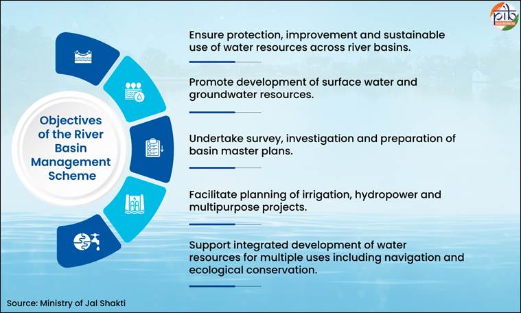
River Basin Management (RBM) is a comprehensive scheme for the management, protection, improvement, and sustainable use of water resources across river basins. These resources include rivers, lakes, streams, groundwater, and associated ecosystems. The approach emphasizes integrated planning and development of water resources to ensure optimal utilization. In India, where river systems are complex and interlinked, basin-level planning has become essential for addressing challenges such as floods, erosion, uneven water distribution, and ecological degradation. Recognizing these challenges, the River Basin Management (RBM) Scheme is being implemented in a structured and scientific manner.
Water has always been central to human survival and development, but in a country as vast and complex as India, managing it efficiently is far from simple. Rivers do not follow administrative boundaries; they flow across states, regions, and even international borders, carrying with them not only water but also challenges such as floods, erosion, pollution, and uneven distribution.
It is in this context that the River Basin Management Scheme emerges as a crucial and forward-looking step toward strengthening water governance. Rather than treating water resources in isolation, the scheme adopts a basin-level approach, recognising that rivers, groundwater, ecosystems, and human activities are deeply interconnected and must be managed in an integrated manner.
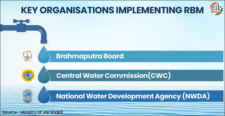
RBM is a central sector scheme of the Department of Water Resources, River Development, and Ganga Rejuvenation under the Ministry of Jal Shakti. The scheme aims to facilitate integrated planning, investigation, and development of water resources at the river basin level, including both surface water and groundwater systems. It is implemented through three key organisations—namely, the Brahmaputra Board, the Central Water Commission (CWC), and the National Water Development Agency (NWDA)—and supports activities such as the preparation of basin master plans, the survey and investigation of projects, and the planning of multipurpose projects.
At its core, the scheme reflects a shift from fragmented water management practices to a more scientific, coordinated, and sustainable framework. Traditionally, water planning in India often focused on individual projects such as dams or irrigation systems without fully considering their broader impact on the entire river system. The basin-level approach changes this by viewing the entire river basin as a single unit, enabling policymakers to balance competing needs such as irrigation, hydropower generation, ecological preservation, and drinking water supply. This is particularly important in a country where water demand is rising rapidly due to population growth, urbanisation, and industrial expansion.
The institutional structure of the scheme is designed to bring together expertise from multiple agencies, each playing a specific role in planning and implementation. Organisations like the Brahmaputra Board focus on flood management and basin planning in the North Eastern Region, an area that experiences frequent flooding and riverbank erosion. Meanwhile, the Central Water Commission undertakes detailed surveys and prepares project reports that form the basis for infrastructure development, while the National Water Development Agency works on long-term strategies such as interlinking rivers and balancing water availability across basins. This multi-institutional framework ensures that planning is both technically sound and regionally responsive.
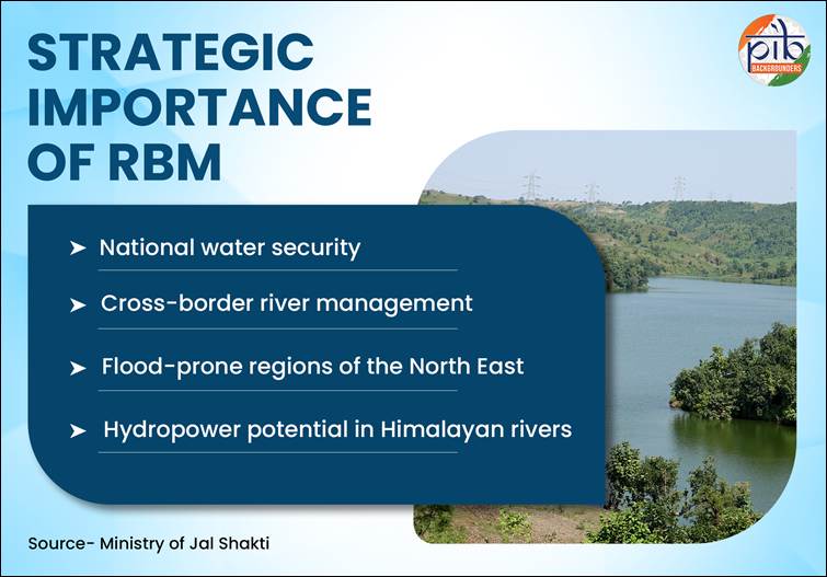
One of the most significant aspects of the scheme is its geographical focus. It prioritises river basins such as the Brahmaputra River, Barak River, Teesta River, and Indus River, which are not only water-rich but also strategically important. These basins play a vital role in national water security, support large populations, and are often located in ecologically sensitive or geopolitically significant regions. For instance, the Indus basin is critical for Jammu & Kashmir and Ladakh, while the Brahmaputra basin is prone to devastating floods that affect livelihoods and infrastructure every year. By focusing on these regions, the scheme aims to address both developmental and environmental challenges in a targeted manner.
Financial commitment is another indicator of the seriousness of this initiative. With a proposed outlay of ₹2183 crore for the 2026–27 to 2030–31 period, fully funded by the central government, the scheme demonstrates a sustained investment in long-term water planning. This is not a one-time intervention but a continuous process that builds on earlier phases, reflecting an understanding that water management requires persistent effort, regular monitoring, and adaptive strategies.
What makes the scheme particularly impactful is the range of activities it encompasses. Basin planning forms its foundation, involving the preparation and periodic updating of master plans that guide the development and conservation of water resources over the long term. These plans are not static documents; they evolve with new data, changing climatic conditions, and emerging needs. Supporting this planning process are extensive surveys and investigations, including geological studies, hydrological assessments, and data collection. Such groundwork is essential for informed decision-making and ensures that projects are based on scientific evidence rather than assumptions.
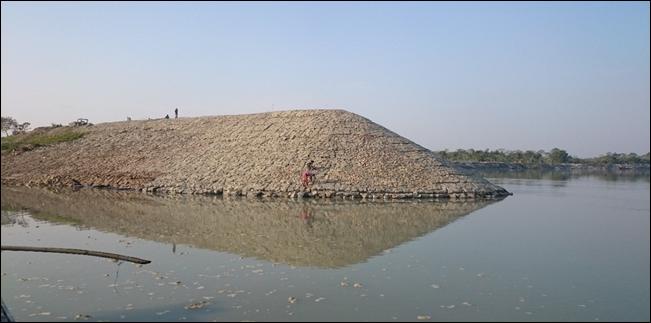
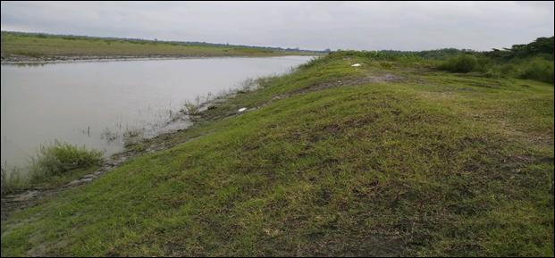
Project development under the scheme focuses on creating Detailed Project Reports for multipurpose initiatives that can address multiple challenges simultaneously. For example, a single project might combine irrigation development, flood control, and hydropower generation, thereby maximising the utility of available resources. In flood-prone regions, specialised measures such as anti-erosion works, riverbank protection, and drainage improvement are implemented to safeguard communities and agricultural land. These interventions are particularly relevant in areas like Assam, where erosion and flooding can drastically alter landscapes and livelihoods.
Another important dimension is drainage development, which addresses waterlogging and inefficient water flow in both rural and urban areas. Poor drainage not only reduces agricultural productivity but also increases the risk of disease and infrastructure damage. By improving drainage systems, the scheme contributes to better land use and overall water efficiency. At the same time, community-based interventions ensure that local populations are not merely passive beneficiaries but active participants in water management. Initiatives such as springshed management and the promotion of indigenous water practices help strengthen local resilience and ensure that solutions are culturally and environmentally appropriate.
Technology plays a transformative role in enhancing the effectiveness of the scheme. Modern tools such as Geographic Information Systems, remote sensing, LiDAR, and drone-based surveys enable precise mapping, monitoring, and analysis of river basins. These technologies improve the accuracy of data, reduce the time required for surveys, and allow for better prediction of future challenges such as floods or water scarcity. Advanced hydrological models further support planning by simulating different scenarios, helping policymakers make informed decisions about resource allocation and infrastructure development.
The progress achieved during the 2021–26 phase of the scheme demonstrates its practical impact. Basin master plans have been prepared and updated, providing a structured roadmap for water resource management. Significant efforts have been made in flood and erosion control, including the protection of vulnerable areas like Majuli Island in Assam. Detailed Project Reports have been developed for multiple projects across key basins, laying the groundwork for future investments in irrigation, hydropower, and flood management. At the national level, progress in river interlinking studies reflects a broader vision of balancing water availability across regions.
Equally important is the scheme’s focus on supporting states and regions with limited technical and financial capacity. Areas such as Jammu & Kashmir, Ladakh, and several North Eastern states often face challenges due to difficult terrain, limited infrastructure, and shorter working seasons. By providing central support, the scheme enables these regions to participate in large-scale water planning and development, ensuring more balanced regional growth.
In a broader sense, the River Basin Management framework represents a shift toward resilience and sustainability. It acknowledges that water challenges are becoming more complex due to climate change, which is altering rainfall patterns, increasing the frequency of extreme weather events, and putting additional pressure on existing resources. By adopting an integrated, technology-driven, and participatory approach, the scheme lays the foundation for a more secure and sustainable water future.
Ultimately, the success of such an initiative will depend not only on infrastructure and investment but also on coordination among institutions, effective implementation on the ground, and active involvement of communities. Water governance is as much about people as it is about policy. When scientific planning, institutional collaboration, and public participation come together, the result is a system that is not only efficient but also equitable and resilient.
The River Basin Management framework represents an important step toward strengthening India’s capacity to manage its river systems in a coordinated and forward-looking manner. By promoting scientific assessments, infrastructure readiness, and institutional collaboration, the initiative has laid the groundwork for more resilient water systems across strategically important regions. Its continued implementation will play a vital role in addressing emerging challenges such as climate variability, population growth, and increasing demand for water across sectors. At the same time, sustained technical support and targeted investments will help vulnerable and remote regions build stronger systems for flood protection, water storage, and resource utilization. In the long run, the success of River Basin Management will depend not only on physical infrastructure but also on sustained coordination among institutions, adoption of modern technologies, and community participation. Together, these efforts contribute to improved water security, greater regional stability, and more balanced socio-economic growth across the country.
Comments are closed.