India’s Multi-Hazard Early Warning Decision Support System
A Digital Transformation in Forecasting and Disaster Risk Reduction
S Ahmad
On a subcontinent where the monsoon shapes destinies, cyclones redraw coastlines, and heatwaves test the limits of endurance, weather is never a mere backdrop—it is a force that influences livelihoods, governance, and survival itself. India’s geography makes it uniquely vulnerable to extreme weather events. From the cyclone-prone eastern and western coasts to the floodplains of the Ganga and Brahmaputra, from drought-affected central districts to landslide-prone Himalayan regions, the country faces a complex and overlapping risk landscape. In recent years, climate variability has intensified these threats, turning once-in-a-decade events into recurring challenges.
India is highly vulnerable to extreme weather events such as cyclones, floods, heatwaves, droughts, and landslides due to its diverse geography, long coastline, and monsoon-dependent climate. According to the India Meteorological Department (IMD) and the Ministry of Earth Sciences, India experiences hundreds of extreme weather events every year, with floods affecting nearly 40 million hectares of land and heatwaves becoming more frequent in recent decades. Over 75% of India’s districts are exposed to multiple climate hazards, while cyclones and floods alone account for the majority of disaster-related losses, according to the Council on Energy, Environment and Water (CEEW). In this context, the in-house development of a Multi-Hazard Early Warning Decision Support System (MHEW-DSS) is a timely and strategic step, as accurate forecasting and integrated risk analysis significantly reduce disaster losses, enable early evacuation and preparedness measures, and strengthen public safety by translating complex meteorological data into actionable warnings for governments, communities, and emergency responders.
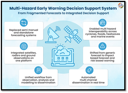
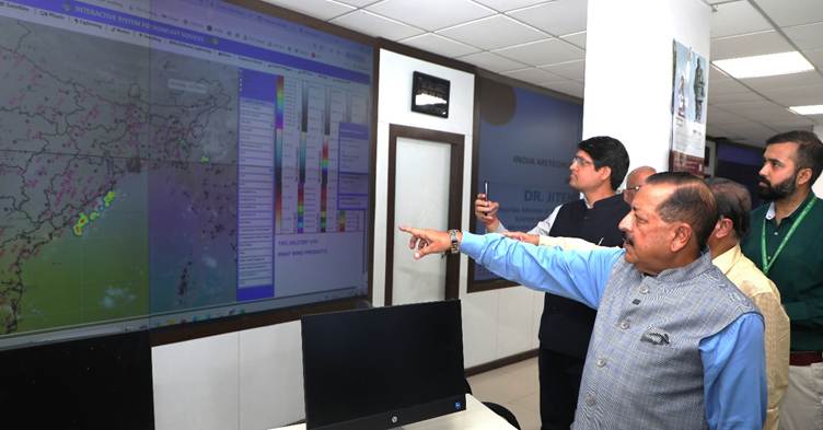
Against this backdrop, India’s Multi-Hazard Early Warning Decision Support System (MHEW-DSS) marks a decisive shift in how the nation anticipates, prepares for, and responds to disasters. Developed in-house by the India Meteorological Department (IMD) under Mission Mausam, the system represents far more than a technological upgrade. It is a structural transformation—moving India from fragmented, semi-manual forecasting processes to an integrated, automated, impact-based early warning architecture.
Launched in January 2024, the MHEW-DSS is now operational in real time, converting vast streams of meteorological data into actionable intelligence.
The MHEW-DSS is an advanced digital forecasting platform developed by the IMD using open-source technology and in-house expertise. Introduced as a landmark digital transformation initiative under Mission Mausam, the system strengthens India’s real-time weather monitoring and early warning capabilities.
Its impact is measurable and significant: forecast preparation time has been cut in half, accuracy has improved by nearly one-third, and evacuation costs—particularly in cyclone-prone regions—have fallen dramatically over the past two decades.
Most importantly, impact-based, location-specific warnings now reach nearly 80 percent of the population across India and neighbouring regions. In a country where minutes can mean the difference between safety and catastrophe, this transformation is historic.
The primary objective of the MHEW-DSS is to build an integrated and indigenous forecasting system capable of delivering accurate, real-time, and impact-based multi-hazard forecast across India.
The system is designed to empower forecasters, decision-makers, and communities by improving information flow and enabling timely early warnings. Through these capabilities, the system supports impact-based forecasting and risk-based warnings, allowing IMD forecasters to translate complex meteorological data into actionable information for users.
This approach strengthens disaster preparedness and enhances public safety by ensuring that early warning information is accessible, reliable, and relevant for different sectors and communities.
From Forecasting Weather to Forecasting Impact
India experiences hundreds of extreme weather events every year. Floods affect millions of hectares of land, heatwaves are growing in frequency and intensity, and cyclones continue to threaten densely populated coastal districts. More than three-fourths of India’s districts are exposed to multiple climate hazards. Historically, while the country has made steady improvements in forecasting accuracy, the system often struggled with fragmentation—data sources were siloed, chart plotting was manual, and coordination across sectors required time-consuming processes.
The MHEW-DSS addresses this challenge by integrating real-time observational data from satellites, Doppler weather radars, automatic weather stations, ocean buoys, ships, and aircraft into a unified digital platform. Instead of isolated datasets being processed independently, the system standardises, analyses, and visualises them through Geographic Information System (GIS)-based tools. This unified approach allows meteorologists to see the full picture instantly—across regions and across hazards.
At its core lies the Weather Analysis and Forecast Enabling System (WAFES), a GIS-driven analytical engine that allows forecasters to compare real-time observations with multiple model outputs. Through ensemble forecasting, bias correction, and multi-model consensus techniques, the system selects the best-performing predictions and refines them for improved reliability. This has extended forecast lead time from five to seven days—an increase that significantly strengthens preparedness planning for governments and communities alike.
Yet the most critical shift is conceptual rather than technical. The MHEW-DSS does not stop at predicting rainfall, wind speed, or temperature. It translates meteorological information into impact-based warnings. Instead of simply stating that heavy rainfall is expected, it assesses what that rainfall means for agriculture, transport, health services, power infrastructure, or coastal communities. It moves from “what will happen” to “what it will do.”
Colour-coded alerts, sector-specific advisories, and risk-based warnings ensure that information is understandable and actionable. In doing so, the system transforms data into decisions.
Efficiency, Accuracy, and Self-Reliance
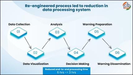
One of the most remarkable achievements of the MHEW-DSS is its operational efficiency. More than 90 percent of weather data processing—including collection, quality control, and integration—is now automated. This drastically reduces human error and accelerates system responsiveness. Over 95 percent of numerical weather prediction inputs are utilised in operational forecasting, ensuring comprehensive risk assessment.
The re-engineered digital workflow has reduced forecast preparation time from six hours to roughly three. During rapidly evolving weather events such as cyclones or severe thunderstorms, this time savings can enable faster evacuation, earlier advisories, and more effective emergency response.
Accuracy has improved by approximately 30 percent. For cyclone forecasting in particular, the reduction in landfall point error in three-to-five-day forecasts has produced measurable public value. Between 1999 and 2024, improved prediction accuracy helped reduce evacuation costs to nearly one-third of earlier levels. Better precision means authorities can evacuate targeted areas instead of entire coastlines, minimising disruption and economic loss.
The system has also generated estimated savings of around ₹250 crore by eliminating reliance on foreign vendors and proprietary systems. Built using open-source technologies and in-house expertise, it strengthens India’s technological self-reliance. Digital transformation has reduced manual chart plotting across 40 IMD offices, saving approximately 23 tonnes of paper annually and cutting associated water and electricity use. Annual manpower optimisation has resulted in significant cost efficiencies, while the streamlined system avoids unnecessary duplication of effort.
This is digital governance delivering tangible dividends—financial, environmental, and operational.
Sectoral Impact: Protecting Lives and Livelihoods
The real measure of any early warning system lies in its human impact. The MHEW-DSS extends beyond meteorological departments to reach farmers, fishermen, transport authorities, health officials, energy managers, and local governments.
In cyclone and marine safety, the system issues timely alerts for storm surges, high winds, heavy rainfall, and rough sea conditions. Fishermen receive specific advisories when wind speeds exceed safe thresholds or when seas turn hazardous. Warnings are disseminated through SMS, mobile apps, broadcast media, and digital platforms. During recent severe cyclonic events such as Biparjoy and Dana, accurate forecasts enabled timely evacuation and contributed to the prevention of casualties in affected regions.
For public health, the system strengthens heatwave preparedness. Heat action plans, cooling centre arrangements, hospital readiness measures, and targeted advisories for vulnerable groups are supported by precise temperature forecasts. Weather-linked disease surveillance benefits from climate data, helping anticipate outbreaks of vector-borne illnesses such as dengue and malaria.
The energy sector relies heavily on weather intelligence. Solar radiation forecasts guide solar power generation planning; wind forecasts inform turbine operations; rainfall predictions assist hydropower management. Early warnings protect power infrastructure from extreme weather damage. Automation has improved grid planning and reduced infrastructure vulnerability.
In water resource management, accurate rainfall and monsoon predictions support reservoir operations, flood mitigation strategies, irrigation planning, and groundwater conservation. Farmers benefit through twice-weekly agrometeorological advisories that guide sowing, irrigation, fertiliser application, and harvesting decisions. Evidence suggests that farmers who use such advisories report significantly higher annual incomes compared to those who do not. In rain-fed districts, the economic benefits of widespread advisory adoption run into thousands of crores annually.
Livelihood protection extends to daily wage earners, tourism operators, transport services, and small businesses. Timely information allows activity rescheduling, asset protection, and safer planning.
More than 200 organisations—including national planning and disaster management bodies—now use the IMD’s digital applications. This cross-sector adoption reflects growing trust in the system’s reliability.
Institutional Backbone and Global Leadership
The MHEW-DSS operates within a robust institutional framework led by the Ministry of Earth Sciences and the India Meteorological Department. Established in 1875, the IMD has evolved into a technologically advanced forecasting agency serving sectors ranging from aviation to agriculture.
Mission Mausam, approved by the Union Cabinet in 2024, provides the strategic vision for strengthening forecasting resolution, accuracy, and lead time. The integration of digital tools under this mission ensures sustained capacity building, continuous system upgrades, and long-term sustainability.
India’s role as a Regional Specialised Meteorological Centre under the World Meteorological Organization further extends the system’s impact. Forecasts and severe weather advisories support countries across the North Indian Ocean and Asia-Pacific region, enhancing regional cooperation in disaster risk reduction.
National and international recognition—including prestigious awards in e-governance and disaster risk reduction—reflects the system’s operational success and global credibility.
A Weather-Ready, Climate-Smart Nation
The philosophy behind the MHEW-DSS is simple yet powerful: every household, every sector, and every region deserves timely and actionable weather information. The vision of a “Weather Ready and Climate Smart Nation” is not rhetorical—it is operationalised through digital infrastructure, scientific rigour, and institutional coordination.
In an era of climate uncertainty, early warning systems are among the most cost-effective investments a nation can make. They reduce loss of life, limit economic damage, and enhance public confidence. They convert uncertainty into preparedness.
India’s Multi-Hazard Early Warning Decision Support System demonstrates how digital transformation, when anchored in public service and scientific excellence, can reshape disaster governance. By integrating real-time observations, advanced modelling, GIS-based analytics, and structured dissemination into a single ecosystem, the system transforms forecasts into foresight and data into decisive action.
In doing so, it not only strengthens national resilience but also positions India as a global leader in multi-hazard early warning systems—proving that in the face of nature’s unpredictability, preparedness is power.
MHEW-DSS has strengthened preparedness across environment, energy, health, agriculture, livelihoods, and governance. It has reduced loss of life, limited economic damage, improved service delivery, and enhanced public trust through consistent and impact-focused warnings. The system demonstrates how technology-driven early warning delivers measurable public value at the national-scale and positions India as a global leader in multi-hazard early warning systems.
Comments are closed.